Getting GCPs (optional)
It's highly recommended to use Ground Control Points (GCPs) if your images are not georeferenced. When images are not georeferenced, not using GCPs will cause your models to be improperly oriented and scaled.
A ground control point is a precise position measurement taken on the ground, often using a high-accuracy GNSS device. These measurements are typically collected near easily recognizable features like street corners or by positioning visible markers on the terrain.
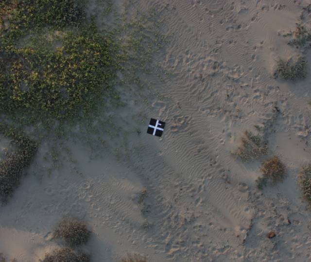
Images containing visible markers can be tagged by establishing a mapping between the image location of the markers and their real-world positions.
The recommended number of ground control points typically ranges from 5 to 8, evenly distributed across the surveyed area. Using more than 8 ground control points doesn't necessarily improve accuracy.
When the same marker is visible in multiple images, it should be tagged in each of those images. Ideally, each marker should be tagged at least 3 times. This means a marker should be captured in at least 3 images.
You can also measure the GCP coordinates from other sources such as older maps of an area or LiDAR surveys.
Field Measuring
This requires the area to be accessible. You must take note of the coordinate system that you will be using to collect your measurements. I suggest to download a CSV template from the GCP Interface for recording your measurements.
After placing your targets evenly across the area (preferably not at the edges), record their location using a GNSS device.
Make sure your ground control points are clearly visible and not obstructed by or placed near trees, buildings or other objects. There must be a clear line of sight between the camera and the ground control point, otherwise accuracy might be affected.
Other Sources
- High accuracy sources include existing maps of the same area.
- From a basemap (e.g. Google Maps). The accuracy of these points might not be very good, but they can still be useful if the images in your project lack georeferencing. These can also be useful if the goal is to align the results perfectly with the basemap.
To create GCPs from basemaps, the GCP Interface has a function that lets you select points on a map. You can access this function by clicking the Create GCP File From Map button.
Create a gcp_list.txt
After you've measured your GCP targets, read How To Use Ground Control Points to create a gcp_list.txt file which will be used for processing.